AERIAL ARCHAEOLOGY AT THE IoA PRAGUEPRIMARY AIMS & ACHIEVEMENTS TO DATE |
Back to AERIAL ARCHAEOLOGY AT THE IoA PRAGUE
|
The programme of aerial survey and the photographic documentation of historic landscapes is one of the themes defining the work of the Institute of Archaeology of the Czech Academy of Sciences in Prague. It is part of a strategy of matching non-destructive techniques in archaeology to the needs of theoretical research and protection of the cultural heritage. This strategy has been applied to spatial archaeology since the early 1990's. |
1. Further to the theoretical formulation of questions regarding landscape and settlement archaeology - the resolution of which is one of the basic tasks of the Institute of Archaeology - to conduct aerial surveys, to identify new settlement areas of prehistoric and/or medieval age, and to both map and process information about settlement topography in order to use it to further archaeological theory and protect the cultural heritage.
2. To gradually create a central record of the aerial discovery and documentation of sites and landscape transects. This record is managed under the general name of the Aerial Photograph Archive, which comprises:
a library of aerial photographs together with an archive of negatives, diapositives, compact discs and digital video recordings
textual and pictorial databases.
3. To generally deepen the methodological relationship between aerial archaeology and other non-destructive prospection methods.
4. To gradually complete the aerial photodocumentation of Bohemian historic landscapes.
1. A substantial increase in the number of known settlement locations (cadastre sites), particularly in Central Bohemia and NorthWest, the "early settlement regions". This relates in particular to those parts of the landscape with well-formed terraces of light, sandy soils, particularly along the great Bohemian rivers such as the Vltava (Moldau) between Kralupy and Mělník, the Labe (Elbe) between Kolín and Lovosice, and the Ohře (Eger) between Postoloprty a Litoměřice), and their tributaries To date, some 500 settlement sites have been discovered and documented by means of vegetation and soil marks.
2. The discovery of a qualitatively new type of site, the existence of which in the Bohemian historic landscape was virtually unknown. These are enclosures, or ditches (sometimes several concentric ditches) and palisade trenches that demarcate a particular area (usually round or oval in plan), often with interrupted entrances. The diameters of such features vary from several metres to several hundred metres.
3. The identification of new, fortified, upland locations - hill-forts.
4. The management and permanent enlargement of an archive of aerial photographs and digital video recordings of Czech historic landscapes, or individual categories thereof (buried settlement areas, traces in relief of prehistoric features, castles, fortified manors, chateaux, historic town centres, villages, monasteries, solitary churches etc.) and landscape settlement zones/ecozones. The archive contains pictorial records of around 1000 sites.
In 1997 the Institute of Archaeology of the Czech Academy of Sciences published a monograph on the history of aerial archaeology in Bohemia and on the results to that time of the 1992-1996 aerial archaeology programme.
 |
| Fig. 1. Round feature with entry 'corridor', in the vicinity of ditched enclosures, perhaps barrows. Cropmarks, drawn from aerial photography.Enlarge |
 |
| Fig. 2. Prehistoric settlement of many residential units (large rectangular features) and pits (dots) as evidenced by cropmarks.Enlarge |
 |
| Fig. 3. Part of an extensive round enclosure formed by two concentric ditches and the line of a basic palisade trench. Cropmarks. Enlarge |
 |
| Fig. 4. Tumulus burial ground (in front of the road) and the sunken dwellings of a prehistoric settlement (outside the road). Cropmarks. Enlarge |
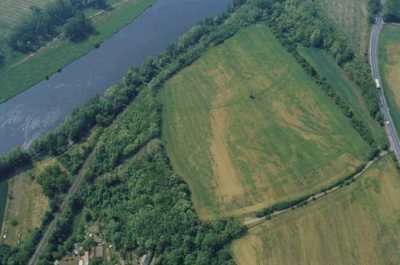 |
| Fig. 5. Example of a site in a strategic position over a river bend, and fortified by a ditch system. Defences built in dominant locations have been identified at several sites in recent years, particularly in Central Bohemia. Cropmarks. Enlarge |
 |
| Fig. 6. Title page of the monograph "Letecká archeologie v Čechách" ("Aerial archaeology in Bohemia") by Martin Gojda, published 1997 by the Institute of Archaeology of the Czech Academy of Sciences.Enlarge |