|
AERIAL ARCHAEOLOGY - A BROAD OVERVIEW HISTORY & THE PRESENT |
o Back to AERIAL ARCHAEOLOGY - A BROAD OVERVIEW - Introduction
o THE BEGINNINGS OF FLIGHT AND PHOTOGRAPHY (1858 - 1896)The first aerial pictures (taken from balloons) |
o THE EARLIEST AERIAL PHOTOGRAPHS OF HISTORIC AND ARCHAEOLOGICAL MONUMENTS (1896 - 1922)Balloons, and later aircrafts. England (Stonehenge - 1906), Italy (Rome, Ostia, Pompeii - 1896 - 1911), Germany (Vilbel - 1912), Macedonia (1916 - L. Rey). Near/Middle East - G.A.Beazeley (English): RAF pilot -
ancient Samara
|
o THE APPEARANCE OF AERIAL ARCHAEOLOGY AND DEVELOPMENT OF BASIC METHODS OF AERIAL PROSPECTION (1922 - 1945)ENGLANDO.G.S.CRAWFORD (1886 - 1957): The first archaeologist to be appointed to the Ordnance Survey, discoverer of prehistoric field systems, creator of the aerial photographs - evaluation - mapping - interpretation approach, founder of the journal Antiquity (1927) and its editor until 1957, the founder of aerial archaeology. Literature: "Wessex from the Air" (1928) , Air Survey and Archaeology (1924) George W.G.Allen: pilot, engineer, and inventor. Worked on the development of oblique photography and detection on the basis of cropmarks. FRANCEAntoine Poidebard (b.1878): extensive surveys of arid and steppe regions in the Near East: Syria, northern Mesopotamia, and Iran. Research into Roman monuments along the limes in the 1920's & 1930's. Pioneer of the aerial survey of monuments buried beneath the sea (Sidon, Tyre). Jean Baradez: military pilot, active in the 1940's. Surveys in North Africa (Morocco, Algeria, Tunisia); study of the Roman landscapes, and in particular the southern frontier of the Roman Empire (centuriation, the limes and fossae). GERMANYFrom 1928: aerial photographs taken of an archaeological site (Haithabu, settlement on coastal sandbanks) by the firm Hansa Luftbild. From 1935: aerial photographs of archaeological sites taken by the Luftwaffe for recording purposes. 1937: The archaeologist Joachim Werner successfully completes a course in aerial navigation.
|
o EXTENSIVE DISCOVERIES OF BURIED LANDSCAPES, INTENSIVE SURVEYS AND THE BUILDING OF AERIAL PHOTOGRAPH ARCHIVES (1945 - 1965)ENGLAND1946 - 1948: complete vertical photography of the England by the RAF (over 4 million pictures in all). John Bradford: in Italy, discovers Neolithic landscapes and Roman centuriation (Apulia - Tavoliera), and extensive tombs (Etruria). Literature: "Ancient Landscapes" (1957) Kenneth S. St Joseph: founder of the Centre for Aerial Photography at Cambridge University (CUCAP) in 1948 (which since 1960 has owned its own aircraft), extensive discoveries over practically the whole of Britain (Roman military and marching camps, prehistoric settlements, tumuli, deserted Medieval villages etc.), huge growth in the number of accessible aerial photographs. Literature: "Medieval England" (co-author M. Beresford) D. Riley: Literature: "Aerial Archaeology in Britain" J. Pickering GERMANYIrwin Scollar: (by birth an American, electrical engineer): worked in the Rhineland, discovering large numbers of Roman military monuments, and creator of a computer program to rectify oblique photographs. FRANCERaymond Chevallier: in 1961, became the first person in France to lecture in aerial archaeology, at the École pratique des hautes études of the Sorbonne in Paris. Literature: one of the editors of the Atlas of Roman centuriation networks (produced on the basis of some 15000 aerial photographs). 1963: major international exhibition on aerial archaeology held in Paris.
|
o THE INTEGRATION OF AERIAL SURVEYS INTO LANDSCAPE ARCHAEOLOGY PROJECTS, AND AERIAL PROSPECTION IN CENTRAL EUROPE (1965 - 1999)Main characteristics:A. Institutionalisation of aerial archaeology. GREAT BRITAIN:From 1965: foundation of Aerial Survey units within the Royal Commissions for Historic Monuments (England - 1965; Scotland - 1976; Wales -1986). J. Hampton R. Palmer: rectification, interpretation and mapping. R. Whimster: Literature: "The Emerging Past. Air Photography and the Buried Landscape". D. Wilson (CUCAP): Literature: "Air Photo Interpretation for Archaeologists". FRANCE:Roger Agache: active in Picardy, first person anywhere to recognise "damp sites". René Goguey: Burgundy, aerial reconnaissance mission to Hungary (1990's), co-operation with the University in Budapest.
GERMANY:Otto Braasch (b.1936): leading figure of 1980's and 90's aerial prospection and photography at a pan-European level. From the second half of the 1970's, worked on the systematic survey of Bavaria and Baden-Würtenberg, from the early 1990's on prospection in the new unified country (identified thousands of new sites). Integrates aerial archaeological survey in the countries of the former Soviet Bloc. Literature: "Unterirdischer Bayern" (co-author), "Unterirdischer Baden-Würtenberg" (co-author).
|
|
History to the end of the 1980's: |
|
|
Bohemia: |
1967: French exhibition on aerial photography at the National Museum in
Prague.
|
|
Moravia: |
1949: the earliest aerial photographs of archaeological monuments: Žuráň
(Podolí). |
|
Slovakia: |
1967: first archaeological site identified by aerial survey (the Slavic hill-fort at Majčichov). |
|
Germany: |
F. Schlette (late 1950's) & G. Wetzel (late 1970's). |
|
History after the fall of the Iron Curtain |
|
|
1994: |
First international conference on aerial archaeology in the countries of Central Europe (Kleinmachnow, Germany). |
|
International projects within the framework of the EU RAPHAEL program: |
|
|
1997: |
International conference and opening of an international travelling
exhibition (Prague, National Museum). |
|
|
|
|
1998: |
Summer training course in aerial archaeology (Leszno, Poland). |
|
1998 - 1999: |
The travelling exhibition on aerial archaeology is displayed in Dresden (Germany), Pécs (Hungary) and Bratislava (Slovakia). |
The aim of these projects is the systematic monitoring of areas of interest, and the prospection and recording of hitherto unknown features that document human (settlement) activity in the past, as well as the further documentation of such features (both in detail and in their landscape contexts) by photography or film. Documentation in these projects often concerns all of the historic and archaeological monuments in the landscape that are preserved in a more or less visible form. Aerial photography serves both to ascertain the state of preservation of monuments, or changes in it over time, and enable identification of features on the ground (geodetic measuring-in). All of this makes their practical and legislative protection easier.
Aerial survey is an inseparable part of so-called "landscape" projects, i.e. research aimed at settlement history in specific areas of interest (regions), the study of settlement dynamics (continuity of settlements or burial areas), the density and dispersal of settlements in the landscape and features in recorded areas, the identification of important nodes in the prehistoric settlement network (enclosures and hill-forts, ritual and ceremonial sites - roundels etc.) and analysis of the relationships between settlement areas and such nodes in the prehistoric landscape.. Data obtained by aerial/archaeological surveys in such projects are increasingly being stored in digitised formats and integrated into modern computerised databases, which enable their spatio-analytical processing (GIS).
Often, both approaches are combined, in particular in long-term projects (or rather, programmes). A typical example is the current completion of large-scale archaeological maps from interpreting aerial photographs, and transcribing identification data from them onto topographical maps (see below - NMP).
It can generally be said that in developed countries, the individual components of projects in aerial archaeology - special research (and sometimes aerial photography), photographic interpretation and rectification, mapping - are performed by specialists, and not by an individual.
The aerial survey department of the National Monuments Record (English Heritage, previously part of the Royal Commission for Historical Monuments in England) is based at Swindon. It conducts systematic aerial surveys in England, and transposes information from photographs to maps.
The National Mapping Programme, the most important project of the 1990's, systematically creates archaeological maps of individual English regions.
Head: R. Bewley
The NATIONAL MONUMENTS RECORD administers the largest archive
of aerial photographs in the United Kingdom, and probably in Europe (around 3.5
million vertical and 700 000 oblique photographs).
Similar NMR aerial survey units exist at Aberystwyth (Wales): C. Musson, T. Driver, and Edinburgh (Scotland): M. Brown, and Cambridge - CUCAP (est. 1948): K. St. Joseph, later D. Wilson, and Air Photo Services R. Palmer (editor AARGnews).
O. Braasch - his work has filled the archives of the provincial monument care offices in various German Lander, particularly Bavaria, Baden-Würtenberg, Lower Saxony etc.
Munich - Bayerisches Landesamt für Denkmalpflege (W. Irlinger, K. Leidorf) - one of the most important centres anywhere in the world for geophysical archaeological survey (H. Becker, J. Fassbinder).
See the history of aerial archaeology (R. Goguey, R. Agache)
Vienna University - archaeology department (M. Doneus): in particular, work with oblique photographs, photogrammetry, and co-operation with geophysicists and three-dimensional reconstructions.
Since the 1990's, the COUNTRIES OF CENTRAL EUROPE have been integrated into research projects, particularly Slovakia (I. Kuzma, J. Rajtár), Slovenia (D. Grossmann), the Czech Republic (M. Bálek, J. Kovárník, Z. Smrž, M. Gojda), Hungary (R. Goguey, O. Braatsch) and Poland (W. Raczkowski, Z. Kobylinski).
This has occurred mainly under the umbrella of the Aerial Archaeology Research Group, an international organisation for those with a professional or amateur interest in aerial archaeology.
|
|
|
Obr. l. Stonehenge, the first air-photographed prehistoric site in Europe. Enlarge |
 |
|
Obr. 2. O.G.S. Crawford on a photograph from 1931, leaving for field survey. Enlarge |
 |
|
Obr. 3.Title page of the Crawford's publication from 1924, about principles in aerial archaeology : the first work of its kind. lého Enlarge. |
 |
| Obr. 4. A. Poidebard fliyng over Roman landscape in Syria. Enlarge |
 |
| Obr. 5. J.K.S. Saint Joseph. Enlarge |
 |
|
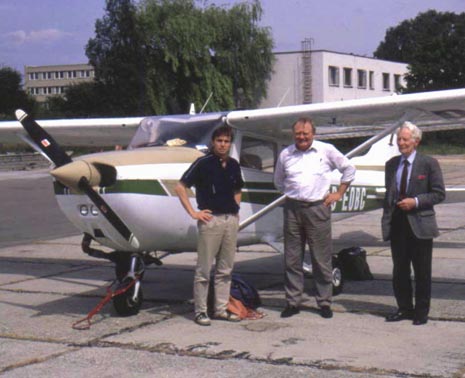
Obr. 6. O. Braasch (centre) in front of his aircraft in the company of J.K.S. Saint Joseph (right) at the Brno airfield in 1992. This year his cooperation with the Czech aerial archaeology project started. |

