AERIAL ARCHAEOLOGY - A BROAD OVERVIEWBASIC PRINCIPLES |
o Back to AERIAL ARCHAEOLOGY - A BROAD OVERVIEW - introduction
In the discovery of buried archaeological features, and those partially preserved in relief, both direct and indirect indicators are studied:
|
DIRECT
|
Soil discolorations - soilmarks |
|
|
Light/Shade - shadow sites |
||
|
Snow - snowmarks |
||
|
INDIRECT INDICATORS |
Changes in vegetation-cropmarks and parchmarks, snowmarks. |
|
|
|
|
|
|
Soils / geological conditions |
Species of plant |
Precipitation |
Aerial reconnaissance is most commonly intended to monitor an area of interest during the periods of crop growth and ripening, when - with the aid of cropmarks - linear shapes and points appear on the surface, mimicking the plans of destroyed features of prehistoric to Early Modern date.
The principle behind these marks arises from the fact that after a feature ceases in its function; its subsequent fill contains richer quantities of phosphates, differentiating its character from that of the surrounding soils. Humus components accumulating in abandoned dwellings or in grave fills cause different chemism. The plants that now grow on onetime sunken features thus have the optimum conditions for life ready made; this is apparent from their density, the height of ears and especially in the colour of the ears. These changes differentiate them from counterparts in the surrounding area during almost all of the growth cycle, and are best visible in grains (particularly barley and wheat).
|
|
|
Fig. 1. The principle of the visibility of sub-surface features in cropmarks. Unlike that growing over (from left) a round pit, a refuse/storage pit, a ditch and a semi-sunken feature, the grain growing above a buried wall is lower and ripens sooner. Enlarge |
|
|
|
Fig. 2. Destruction processes in an archaeological feature - the defences of a prehistoric hill-fort (a ditch and an earth rampart bearing a palisade). The erosion of the rampart and the disintegration of the palisade gradually fill the ditch. The third row (from the top) shows the visible, defunct ditch at present: after ploughing, the fill of the ditch shows up as a darker colour. These are soilmarks (see Fig.). The fourth row shows the feature visible by means of cropmarks (see Fig. 3). Enlarge |
|
|
|
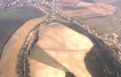
Fig. 3. A triple defensive ditch visible through cropmarks: on the surface of a ripening barley field the archaeological feature shows darker (Hrušovany n.Jevišovkou, south Moravia). Enlarge |
|
|
|
Fig. 4. A prehistoric settlement - sunken-featured huts and pits - shown by cropmarks visible even from the ground. Enlarge |
|
|
|
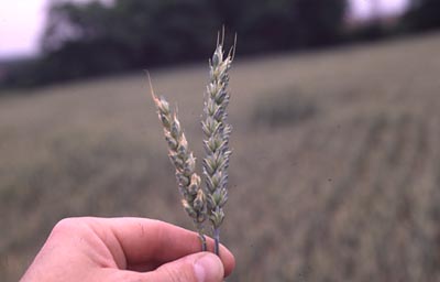
Fig. 5. The difference in growth between ears of wheat away from a sunken archaeological feature (left) and above one. Enlarge |
|
|
|
Fig. 6. A fortification ditch at a prehistoric hill-fort, visible as a darker line. An example of soilmarks (Přerovská hůra/Přerov nad Labem, Nymburk district). Enlarge |
|
|
|
Fig. 7. Prehistoric (so-called "Celtic") fields: the original divides between these small fields are preserved in low relief, and enhanced by the oblique sunlight of the early morning ("shadow sites"): Wiltshire, England. Enlarge |
o Back to AERIAL ARCHAEOLOGY - A BROAD OVERVIEW - Introduction


